A quick tour through the highs and lows of post-World War II Honolulu planning.
As World War II wound down in late 1944, Hawaii Gov. Ingram Stainback, responding to the wartime housing shortage, released a report assessing the need: 56,000 Hawaii residents lacked adequate housing, 30,500 new private dwellings were needed, but only 780 units were planned. Things got so bad in Honolulu that Thomas Square, Kapiolani Park and two private golf courses were considered as sites for emergency housing.
Meanwhile, the city squabbled with the territorial government over highways to the Windward Side, with Honolulu Mayor Johnny Wilson preferring a tunnel route up Kalihi valley, and the Territorial government, armed with federal funds, preferring to tunnel and improve the old Pali highway through Nuuanu. This argument lasted until both tunnels and two modern highways were built in the late 1950s.
The tunnel arguments merged into another city/state standoff, this one over the so-called mauka arterial. The city wanted four lanes, the state six. The six-lane mauka arterial was carved through downtown in 1953; with statehood, it became H-1, aka the Lunalilo Freeway.
The makai arterial, Nimitz Highway-to-Ala Moana Boulevard, was completed in the mid-’50s.

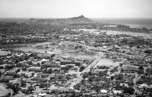
As of 1955, Honolulu’s population was 353,000. The City and County of Honolulu employed 4,157 with an annual budget of $25 million. Civil service workers had become their own political interest group, as UH historian Donald Johnson pointed out in his thorough history, The City and County of Honolulu: A Governmental Chronicle, in 1991.
Housing tracts bloomed deep in the valleys and up the ridges and on the windward side, creating an insatiable demand for stretched-thin city services, while multi-unit walk-ups — or “motel housing” — spread across central Honolulu, still technically a garden city.
A Standard Oil refinery proposed for Honolulu harbor atop Sand Island illustrates the comparative governmental brutishness of the time. Republican Mayor Neal Blaisdell, in office from 1955 to 1969, supported the plan, which, astoundingly, cleared the City Planning Commission and the Board of Supervisors. But the community rose up, and debate raged for three years. Lewis Mumford, author of the 1938 critique called “Whither Honolulu,” wrote from New York that Oahu residents ought to have their heads examined if they allowed such a thing, while Democratic mayoral candidate Frank Fasi made a name for himself opposing it. Finally, in 1957, Standard Oil decided to locate its $40 million refinery far off to the west, way downwind of town, at Campbell Estate’s new industrial park in Kalaeloa.
Powerful residents again rose up when high-rise hotels threatened to march nearly to the Diamond Head lighthouse. And again they prevailed.
Public concerns about air pollution, slum clearance, traffic, sewage and chaotic planning led Oahu voters to approve a new City Charter in 1959. The charter created a four-year-term legislative City Council out of the old Board of Supervisors.
With statehood, Elvis and five-hour jet service from the West Coast, Waikiki — and Honolulu — was ready to soar.
Quickly and without much deliberation, the newly constituted council approved Waikiki’s first true skyscraper, hotelier/architect Roy Kelley’s 23-story Reef Towers on Lewers Street. Other towers followed, prompting concerns about “concrete canyons” in Waikiki. “The sky’s the limit,” observed skeptical editorialists at the Honolulu Advertiser, catching the zeitgeist. With statehood, Elvis and five-hour jet service from the West Coast, Waikiki — and Honolulu — was ready to soar.
The new charter also called for a general planning document for all Oahu, finally adopted as the Oahu General Plan in 1964, after a court order forced the city to act. Quickly cobbled together out of 55 regional plans by the administration of pro-growth Mayor Blaisdell, the plan was criticized for codifying the “spot zoning” so typical of Honolulu governance. It included outlandish ideas like a string of artificial parklands built on reefs, a deep-draft harbor and power plant at Kahaluu, and 350-foot height allowances all over the island.
To combat the city’s worsening traffic, Blaisdell began to look beyond the already deployed tactics of street-widening, one-way streets, more parking lots, etc. Talk about mass transit began in the mid-’60s, about a transit line running from Pearl Harbor to Waialae and beyond, as suggested in the Oahu Transportation Study.
Weak and uneven enforcement of the city’s patchwork of building and zoning codes led to widespread abuse. Mayoral candidate Fasi decried corruption among bureaucrats, “pay-to-play” entered the lexicon and the city carried on with no major prosecutions of anyone.
Blaisdell’s mayoralty was capped by passage of the Comprehensive Zoning Code of 1968, a good example of what is called Euclidean, or single-use zoning, wherein different land uses are separated from each other, and grouped together by use. The CZC and its successor, the Land Use Ordinance, are why there are still no supermarkets near that big pile of residential towers at Kapiolani and Date, and why suburban Hawaii Kai, Mililani and Kapolei make no effort to promote walkability. Like Los Angeles, Honolulu’s genetic mother ship, the automobile ruled — and rules — the place.
Right before the CZC was enacted, developers and individual landowners, anticipating new restrictions on what they could build, made a mad dash to secure building permits. This explains the haphazardness of high-rise/low-rise neighborhoods in Moiliili, Makiki, Punchbowl, the Kinau corridor and Waikiki.

Fasi, a brash renegade in Hawaii politics, served Honolulu as mayor for 22 years in two separate stints: 1969 to 1981 and 1985 to 1994. As much as he presided over the two biggest building booms Honolulu had ever seen, in the late-‘60s/early-‘70s and in the late-‘80s, he had a big impact. He got the windward wetlands of Kawainui and Heeia protected from the feverish imaginings of the ’64 General Plan and cancelled the industrial designs on Kahaluu. He built the controversial, 900-unit Kukui Gardens affordable rental complex downtown.
Revisions to the city’s charter under Fasi carved Oahu into eight districts with each district having its own “development plan.” Localized zoning and subdivision laws had to comport with a district’s development plan, just as a development plan has to comport with broad policy objectives laid down in the general plan. To this day, public review and revision of the development plans, now called “sustainable community plans,” are subject to seemingly constant tactical battle; exemptions are the rule rather than the exception.
Additionally, Fasi designated six special districts within Honolulu requiring special care and special rules: Chinatown, the Capitol District, Punchbowl, Thomas Square, Waikiki and Diamond Head. The goal was to set building height limits to protect view planes, protect historic sites and establish streetscape and architectural guidelines that will preserve the inherent qualities of the districts.
The ramshackle warehouse/residential quarter at Kakaako was an unimproved hole in the middle of Honolulu that was slated to get special-district status during Fasi’s tenure. A city ordinance was enacted calling for thousands of housing units, low-rise and high-rise, with about 80 percent of the district’s sprawling acreage to be somehow reserved for low-, moderate-, and middle-income households in a mixed-use plan. But in 1976, the state abruptly stepped in and transferred Kakaako planning and development over to the state’s own newly formed agency, the Hawaii Community Development Authority, and we now have what we now have.
In 1977, the city designated the Ewa Plain as the site of Oahu’s “second city” on lands owned by Campbell Estate, which finally broke ground as the City of Kapolei in 1990. The land trust was required by law to liquidate in 2007.
Mayor Frank Fasi designated six special districts within Honolulu requiring special care and special rules: Chinatown, the Capitol District, Punchbowl, Thomas Square, Waikiki and Diamond Head.
Another successful grassroots revolt, this one led by bodysurfers and housewives, occurred in the 1980s at Oahu’s southeastern corner, where landowner Bishop Estate had city-backed plans to build a resort and suburbs along what has become known as the Ka Iwi coast, now beloved for its wildness.
Fasi’s managing director, Jeremy Harris, a former Kauai County councilman, automatically became mayor when Fasi resigned to run unsuccessfully for governor in 1994. Subsequently elected mayor three times, Harris became a lightning rod for public frustration about mismanagement in city government.
Plagued by scandal early in his term and mercilessly teased for his attempts to prettify Waikiki by widening sidewalks, installing vintage-looking street lamps, and sprinkling the area with bronze sculptures picked from a catalogue, Harris nevertheless had some good ideas and a messianic zeal for his city that he pulled together under a process he called “envisioning.”
His administration imposed “urban growth boundaries” to stop sprawl and protect most agricultural lands — except for those that had already been indicated for future development by landowners. Harris led the ongoing efforts to revitalize Chinatown and pushed for more “mixed-use” zoning.
About a thousand people showed up on a Saturday night in November 1998 at the new Hawaii Convention Center for Harris’ open-call conference called “21st Century Oahu: A Shared Vision for the Future.” The turnout alone was remarkable, showing that Oahu residents actually cared about planning their city. Out of the conference 19 volunteer “visioning groups” were spawned around the island. City planners asked them to come up with local improvement projects that might help enhance their communities — and awarded them each $2 million from city capital improvement funds to pay for them.
Initial results — new canoe halau, new signage, beautified community gateways, a string of coconut trees planted all along the Waianae coast — were cosmetic if not transformative, and some community activists resented the additional work, the endless meetings and the overlap with the existing Neighborhood Board system. Harris’ ambitiously planned and finely detailed, mid-density, mixed-use ideas for the central King/Young/Beretania spine of central Honolulu — to be served by a bus rapid transit (BRT) system he proposed — ran up against the dense checkerboard of private ownership and feisty homeowners in the area and went nowhere. (The majority of Honolulu house lots are very small, under 10,000 square feet.)
The reign of Mayor Mufi Hannemann (2005 to 2010) and his successors — Peter Carlisle in 2010 and Kirk Caldwell (2013 to present) — has been chiefly marked by an effort finally to bring mass transit to south Oahu in the form of heavy elevated rail. The project has sucked all the air out of the planning room as the city pursues transit-oriented development, diverting most planning and development energies into the installation of a wholly new linear city composed of high-density nodes at key station stops along HART’s 20-mile route from Ala Moana Center out to open fields east of downtown Kapolei.
It’s a completely new paradigm.
Correction: An earlier version of this story said Kirk Caldwell took office in 2010. In fact, Peter Carlisle was mayor from 2010 until defeated by Caldwell in the 2012 election.

